Event Selection
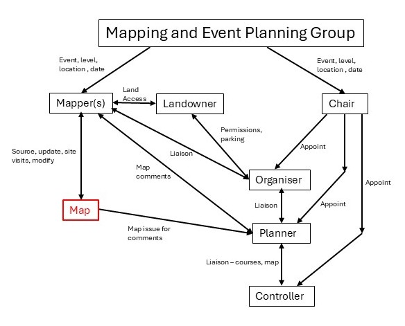
A Mapping and Event Planning Group (MEPG) was set up to identify potential areas, and dates for future TVOC events. The members of this group are Bob Beresford (Mapping Coordinator), Mark Thompson (Saturday Series Coordinator), Neville Baker (Fixtures Secretary) and Paul Eaton (Development Officer) who have a wide knowledge of the TVOC areas (both existing and potential), mapping, event planning and interaction with other events in SCOA and other regions. They meet at regular intervals to produce a plan, usually every 3-6 months.
To provide a definitive forward plan for the next 3 years and a more fluid plan for the following year, the group consider several important factors (not necessarily in order of importance):
- Historical TVOC events (as far back as 2010) to avoid overuse.
- Suitability and size of areas for Level A/B/C events and level D (Saturday Series)
- Access restrictions e.g. shooting estates, out of bounds areas.
- Ease of communication with landowners
- Parking availability (probably the key factor)
- Map status – age of map, update requirements, availability of our limited mapping resource and mapping tools (whether LiDAR was used in the latest update etc)
Post meeting tables are produced to summarise the proposed plan, as in the example for 2026 Level B/C events below:
- Event Plan 2026: Level B/C
| Area | Event Level | Event Date | Mapping Schedule | Mapper | Comment |
| Common Wood | C | 4 Jan 2026 | Autumn 2025 | BB/PB | Event completed |
| Christmas Common – CC | B | 22 Mar 2026 | Winter 2025/26 | MT – final checks | Forestry England permission declined. 2 NT areas agreed |
| Shotover | C (Sat) | 11 Apr 2026 | Ongoing | RW | Permissions done. Note: Sat Series upgraded to Level C |
| Didcot/Ladygrove | C | 27 Sep 2026 | Needs a check, maybe limited extension | BB | Replaces RAF Halton Permissions? |
| Witney/Cogges- extend (urban) | C | 15 Nov 2026 | Desktop underway | BB/PB | Map being extended. Permissions? |
We also produce a plan for Level D events – our Saturday Series event for beginners. These plans are passed to the Chair to find organisers, planners and controllers.
Mapping
After the MEPG have defined the plan, and mappers have been identified for each event, a mapping plan and timescale is agreed.
The latest available map will be checked for suitability and updating requirements.
This can include updating the specification to meet the latest IOF standard for symbols, updating Magnetic North, checking LiDAR availability (using existing or downloading the latest Environmental Agency data), potential for extending the map to new areas, or in some cases excluding areas (e.g. for ash dieback). All this is done using OCAD, our mapping programme, prior to any visits to the area.
Visits to the area require careful consideration to ensure permissions have been obtained, especially for private woodland and shooting estates. Landowners such as Forestry England and Woodland Trust may require licences to be obtained for access. Contact on a visit-by-visit basis with shooting estates are often best done through a gamekeeper (this helps avoid the mappers getting mistaken for a deer during culling activities).
Mapping in woodland is often done a year in advance, so that the map will show the vegetation at the time of the event. Urban events can usually be done at any time of year.
Large areas for Level B, and sometimes C often have 2 mappers working in different areas, and to meet timescales, careful transfer of map updates between mappers is essential to avoid data loss and reworks.
The TVOC mappers have a great deal of commitment to provide the best maps possible for an event. The time taken should not be underestimated. The current mapping effort for the Nettlebed/Bix area (for 2027 Chiltern Challenge) has, so far, required more than 25 full day visits by the mappers and many hours updating the map on OCAD at home.
A series of articles about how we go about mapping using LiDAR data, was produced in 2023: Ever wondered where our maps came from?
Bob Beresford/ Mark Thompson